We’re adding a new page to the NCNAAPT web site, “Becoming a physics teacher.” The goal of the site is to support people who are interested in becoming physics teachers, but have not yet enrolled in a credential program. We have a few links on it, but will be flushing it out over the next few weeks/months. If you have any suggestions of what should go on the page, please email them to web@ncnaapt.org and we’ll incorporate them
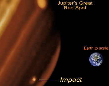
The scar from the probable impact appeared July 19 in Jupiter’s southern hemisphere, and has grown to a size greater than the extent of the Pacific Ocean. This infrared image taken with Keck II on July 20 shows the new feature observed on Jupiter and its relative size compared to Earth. (Paul Kalas ,UCB; Michael Fitzgerald, LLNL/UCLA; Franck Marchis, SETI Institute/UCB; James Graham, UCB)
BERKELEY — Something slammed into Jupiter in the last few days, creating a dark bruise about the size of the Pacific Ocean.
The bruise was noticed by an amateur astronomer on Sunday, July 19. University of California, Berkeley, astronomer Paul Kalas took advantage of previously scheduled observing time on the Keck II telescope in Hawaii to image the blemish in the early morning hours of Monday, July 20. The near infrared image showed a bright spot in Jupiter’s southern hemisphere, where the impact had propelled reflective particles high into the relatively clear stratosphere.
In visible light, the bruise appears dark against the bright surface of Jupiter.
The observation made with the Keck II telescope marks only the second time astronomers have seen the results of an impact on the planet. The first collision occurred exactly 15 years ago, between July 16 and 22, 1994, when more than 20 fragments of comet Shoemaker-Levy 9 collided with Jupiter.
WASHINGTON, July 16 /PRNewswire-USNewswire/ — NASA released Thursday newly restored video from the July 20, 1969, live television broadcast of the Apollo 11 moonwalk. The release commemorates the 40th anniversary of the first mission to land astronauts on the moon.
The initial video release, part of a larger Apollo 11 moonwalk restoration project, features 15 key moments from the historic lunar excursion of Neil Armstrong and Buzz Aldrin.
A team of Apollo-era engineers who helped produce the 1969 live broadcast of the moonwalk acquired the best of the broadcast-format video from a variety of sources for the restoration effort. These included a copy of a tape recorded at NASA’s Sydney, Australia, video switching center, where down-linked television from Parkes and Honeysuckle Creek was received for transmission to the U.S.; original broadcast tapes from the CBS News Archive recorded via direct microwave and landline feeds from NASA’s Johnson Space Center in Houston; and kinescopes found in film vaults at Johnson that had not been viewed for 36 years.
NASA Television will provide an HD video feed of the Apollo footage hourly from 12 – 7 p.m. on July 16 and 17. Each feed is one hour. For NASA TV streaming video, downlink and schedule information, visit:
NASA’s Apollo 40th anniversary Web sites provide easy access to various agency resources and multimedia about the program and the history of human spaceflight, including a gallery of Apollo multimedia features. Visit the site at:
JFK LibraryCelebrating the 40th Anniversary of the First Moon Landing
WeChooseTheMoon.org “The site will plug you into the current state of the mission and has many tangents to keep you occupied during quiet times (especially the “loss of signal” intervals). Keep the site running in the background while you work away at the tasks of the day.” [Thanks, Dean Baird, for the quote]
Physics educators have used photos of natural and man-made breakwaters to show refraction for probably as long as we’ve had photography. But now online mapping web sites (Google, Yahoo. etc.) allow you to find locations near you to make the images more tangible to your students. Oceans and bays are full of images of refraction, but you may also find diffraction patterns in a large lake.
Below is an example from a breakwater in Berkeley, CA, in the San Francisco Bay
View Larger Map
Check water bodies around your institution to find examples you can use with your students. Most mapping sites allow you to save landmarks in a “My maps” section, so once you find a good location, you can save it, then pull it up from a list when you need to show it in class.
One warning: Map sites update their satellite photographs every so often (as the USGS releases newer ones), so check your location before your lecture to make sure your pattern is still there!


 NASA Television will provide an HD video feed of the Apollo footage hourly from 12 – 7 p.m. on July 16 and 17. Each feed is one hour. For NASA TV streaming video, downlink and schedule information, visit: